

Should a prediction based on data be taken seriously?
As talked about on Your Green breakfast and prompted by this article on the BBC's website (Map shows risk to coastal towns as sea levels rise)
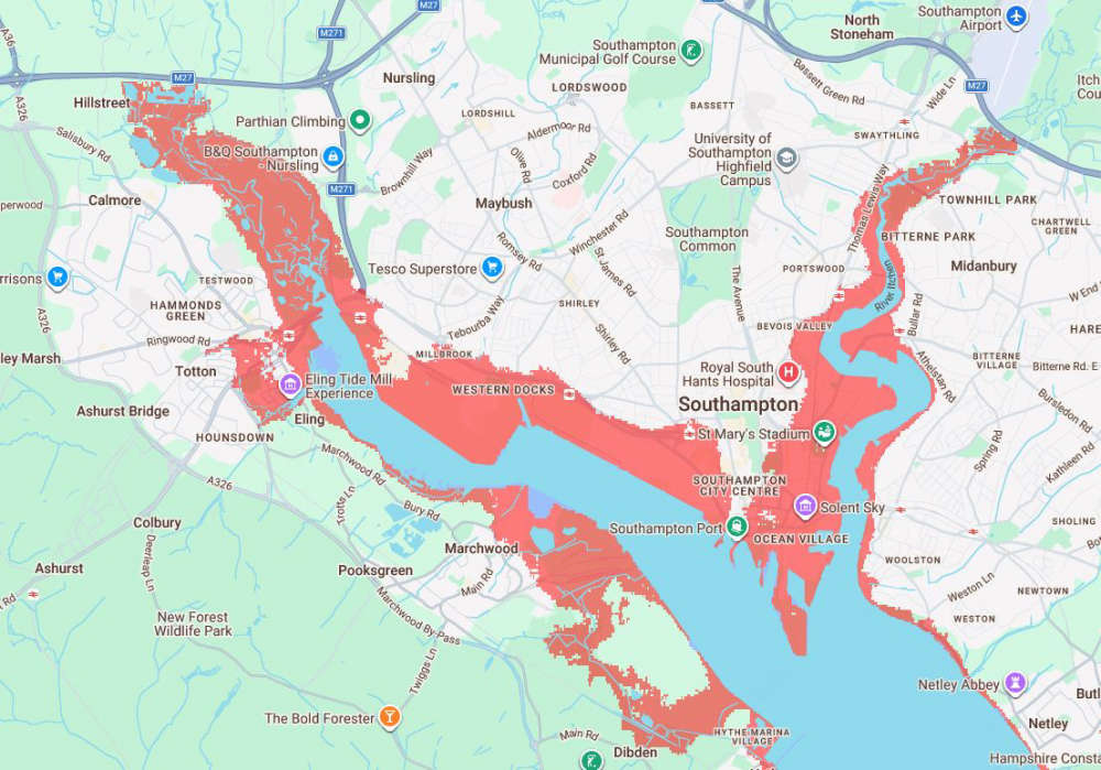
The dramatic map above has been generated from data analised by Climate Central, who describe themselves as “...an independent group of scientists and communicators who research and report the facts about our changing climate and how it affects people’s lives ”
The aspect that concerns the city of Southampton is that in under 25 years, by 2050, the whole of the docks could be underwater, Northam too, and long stretches of shoreline on both banks of the Itchen with the five bridges useless and the railway line ending at St Denys.
It would also have an affect on the opposite banks on Southampton Water with industrial plants at Marchood and Fawley beneath water.
How Accurate Is This Data?
According to the ‘details and limitation’ that Climate Central put on this data
“Climate Central’s sea level rise and coastal flood maps are based on peer-reviewed science in leading journals. As these maps incorporate big datasets, which always include some error, these maps should be regarded as screening tools to identify places that may require deeper investigation of risk.
Outside of the United States, maps are based on global-scale datasets for elevation and tides in addition to sea level rise projections. For the 50 U.S. states, more accurate but still imperfect data are used.
Areas lower than the selected water level and with an unobstructed path to the ocean are shaded red. By default, areas below the water level but that appear to be protected by ridges (and in the U.S., levees) are not shaded.
Our approach makes it easy to map any scenario quickly and reflects threats from permanent future sea-level rise well. However, the accuracy of these maps drops when assessing risks from extreme flood events. Our maps are not based on physical storm and flood simulations and do not take into account factors such as erosion, future changes in the frequency or intensity of storms, inland flooding, or contributions from rainfall or rivers.”
Should Southampton Be Worried?
The obvious answer is yes, and although there are no 100% plans in place the Southampton Renaissance Vision is already winning awards, but it needs much more flesh on the bones and public awareness.
Where it highlights the investment opportunities, it skimps on the possible flooding issue, especially as investors need to be reassured that the docks and local infrastructure will be viable in the years to come.
There’s also the issue of the extreme wet weather parts of Europe is experiencing , especially heavy rainfall and storms, especially if the tide is high.
If you want more information on flood risks in Southampton visit this City Council page Flooding risk
For more environmental news join Xan Phillips 7am every morning on Your Green Breakfast
 Stay safe as extreme heat warning is issued for Hampshire, Dorset and the Isle of Wight
 Win An Epic Piece of World Cup Memorabilia
 Prime Minister Sir Keir Starmer announces resignation plans
 Kidney Appeal Sparks Evie's First Song
 Food Waste Collections Coming To Southampton